
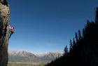
Nepal is a Shangrila destination to all trekkers. The treasure of tourism of the country has not been fully explored yet. Most hidden mysteries of enchantment are under exposition. Natural gifts, panorama landscape, man made heritages, ethno-cultural richness, innocent social setting and hospitality and many more unexplored treasures are dreams for connoisseurs of tourism (Sharma 2005:1). Tourism in Nepal, comprises as one of the key development components, and will remain as significant sector forever for overall sustainable development. Rural tourism in Nepal is a complex multi-faceted activity that includes special nature holidays and eco-tourism comprising walking, climbing, horse riding, adventure, sports, health, hunting, angling, educational travel, arts, heritage and in some areas, ethnic and tourism (Pandey 2005: 23). In spite of that, Nepal is visited simply for few worldly known destinations such as the highest peak in the world, Mt. Everest, the birth place of Gautam Buddha, Lumbini, cultural museum of Kathmandu valley- the ethnic turn table of Asia (Hagan, 1961 in Sharma 2005:1 “The Inclusive Democracy” an unpublished article). But there are places to savior of tourism of all interests which one should not miss. The cheapest with the highest hospitality destination, Nepal can cater tourists of all kinds and from all over the world. Nepal is the melting pot to visit across Asia, particularly to the richest and mysterious destinations- China, India, Hindukush range and Pacific areas. Tourism as smokeless industry has attracted all throughout the world (Kunwar 1997: acknowledgements). Therefore, on the way, spending few days inside Nepal can really provide an opportunity to quench the passion of knowing natural setting of the world. Among different packages of visit to Nepal, trekking can be regarded the most adventurous and enchanting. Treks to round Annapurna, Khumbhu region, Kanchanjunga, Rolwaling, Langtang, Simikot-Mansarobar, upper Mustang, Dolpo, etc are unique destinations. Besides them, a two-day trek with tremendous experience and new insights on the horizon from Khalanga-Jumla to Rara Lake-Mugu cannot be forgotten. So let us go with it today. The Journey to Jumla- Rara A trekker can board in Nepalgunj or Surkhet to Jumla by a twin otter. The experience of plain (terai) with hot climate of Nepalgunj may have one or about the same climatic experience in Surkhet valley, the headquarters of Mid-Western development region. The take-off of the plane gradually leaves the plain land and climbs up the Chure jungle and sights the Surkhet valley with scattered settlement on the red color landscape and snake shaped (bends) of Bheri river and its tributaries. Within 12 to 15 minutes flight from Terai, the topographic diversities change the minds of the plane passengers on the board. Peeping through the window for about 5 minutes to Surkhet valley, the aircraft reaches above Dailekh District or Jagarkot (to you right). The traveler proceeds ahead looking down the curves of Karnali river, panorama of rural settlement, somewhere road constructions (Surkhet-Jumla road) sight along the bank of the river and passing through lowland to upland- hills, villages and bare hills, jungle, brooks and lonely lands. The plane climbs up the altitude leaving behind Surkhet valley and Dailekh district heading towards Kalikot, (to your left) the mountainous district in hill district. Kalikot is known as most inaccessible and remote district among 75 districts of the kingdom (Khadka 20056 BS). The terrace settlement, vertical hill with sparse villages, gorges of the rivers, green hills, laligurans (Rhododendron), sometime you will narrowly view rocky mountains, the sheds of sheep and cows; some Kharkas (seasonal pasturage) with the thatched huts, gothalas (cowboys) and so forth. When you approach to the border of Jumla district you will be narrowly passing through very exciting mountains- Haodelek where few foot-trekkers to and from Jumla-Surkhet are climbing up or down. Then your aircraft will follow the bank of KarnaliRiver toward Jumla region. Close to the hill to your left side you will be watching down the gorge of KarnaliRiver and high green mountains to you right side or left. Now your plane climbs down to Khalanga (open valley) above Talium, Bahara gaon with flat clay roofs clustered settlement and Khalanga (Chandannath VDC)- the headquarters of Jumla as well as Karnali zone. Your plane slightly tilts to left side over Chandannath and finally lands on Jumla airport. This ends your thirty five minutes air journey. When the Surkhet-Jumla road construction completes, the journey will be different one and a different experience. Jumla Khalanga Stay one day in Jumla Khalanga and prepare the journey to Rara for the next day. Visit Chandannath temple, chat with Jumli people and enjoy apples if it is in autumn. Buy necessary trekking foods; hire a porter and a guide cum-cook; since there are not any good hotels and lodges in the trekking route. Collect all necessary goods, food stuffs, sleeping bag, etc. A movie camera or camera with good lens is must. If you are all set, ask blessing from Chandannath and head toward Danfekolek, a steep climb to the sky! The next day from Khalanga, you will proceed ahead to Jumla campus and Technical institute, a nice training vocational training school roofed with high quality local slates. Going ahead leaving behind the technical institute, you will pass through a meadow (Chyare Chaur) where sheep and cows would be seen grazing. For a while, about half an hour you can chat with the  shepherd/cowboys. It is a part of rest. Then upto the foot hill of Danfekolek, you will enjoy easy walking as usual in your hometown or resident area. Then enjoy fresh water, get adequate rest and even light snacks. Now begin the steep climb up the Danfe hill. Go along the curly track, get short pauses (rest) after 10 to 15 minutes, view and enjoy green meadows, far off technical institute and partial view of the Khalanga bazaar and government office buildings. Whenever you meet locals (people) coming from other side u can ask them how far the top is or at what time you will be at Tharmare, a rest café beyond the Danfe peak. It will give you a new hope, relax and opportunity to know the way of behavior of the local people. To climb up this hill you are advised to enjoy a pack of glucose biscuits with local water or chewing gum or at least polo which you have bought in Nepalgunj or Khalanga. O.K after one and half or two hour you will be on the top of the Danfe pass. Get rest in the Chaupari (rest spot) about an hour, view high mountains around with chill air, the Khalanga valley and far away as you can. Do about half dozen photo snaps, over there. Here you may feel a little bit of suffocation due to the high altitude. It. is about 14000 feet height. If you are much tired enjoy light snacks, then move ahead toward Tharmare. Again you will walk through another meadow (Khalichaur), a fantastic solitary place to camping and hiking. Here you will find cattle grazing- sheep, pony, yaks and cows. But here, you will see no sign of human settlement i.e. no houses, farms and even village. You are completely with the nature either blue sky over your head or jungle and grassy land around you. Or simply the chirp sound of birds. If you are lucky Danfe, the national bird, may be sighted and far away cattle grazing scene are the usual phenomena. If you are much interested to know about the Kharkha, a seasonal pasture, spend a day with the shepherds (gothalo) who may be with the cattle under a big tree or inside a plastic tent or under a cave. You will find them either knitting woolen/allow thread and weaving woolen blanket such as radipakhi, lieu, kamlo and their own garments or playing cards, smoking attar (ganja) and hukka (local smoke). They spend such life about 5/6 months and when the autumn falls they come down to their settlement or to lowland. When it is spring, they again go up for Kharka. This is the usual cycle of their life and it is found in other parts of Jumla and Mugu districts. After half an hour walk or so you will be at the Tharmare shed (café) where you will be served black tea, biscuit, chowmin and sometimes local mutton. Thar means wild goat and Tharmare means a hunting spot where Thar used to be hunted by the locals. After having your hot black tea or chowmin at the Tharmare bhatti, you have to pass
  through the jungle and climb down to Neurigadh brook. It will take an hour to get there. Now there you will find about a dozen houses with few Bhattis (tea stalls). If you are there by 3 o’clock or so and not much tired, go ahead up to Kabra and stay there. Otherwise stay at Neurigadh for that night because Kabra has single Bhatti and no other houses. Bhattiwal will provide you dhulo (roti) and fresh green vegetable mixed with highland potato (tasty and unique). If you have your own scheme, manage a tent and get it with your trekking team. On the next day, get up early, have your tea and breakfast then march ahead to Chautha. On the way you will find few primitive types of settlements with few tea stalls. You have to go straight neither climb up nor down. Chautha is a junction to Sinja and Mugu destination. There are a dozen houses. You will see more than one Bhattis. Food items may be more and even the quality of food and shelter are better there. A visit to Sinja, a historically important place for humanities development i.e. Nepali language and tribal expansion, will have a separate chapter of trekking. It was the capital of Nepal during since the rule Nagraj in Karnali up to Challa dynasty in medieval Nepal Khadka 2056 BS: 168). After spending one and half hour lunch time, you climb up the Ghuchhiko Lek. Climbing up through the jungle of pine and Bhojpatra trees you will be lost without any sign and scene of human settlement. During an hour climb up, you will be with the nature- steep rock, century old forest, chirp of birds and murmuring brook as well as trees. Now you are in the Rara National Park. You have chances of sighting Danfe, wild bore, bear and leopard. Before you get to the top of the Ghuchhiko Lek, you have few Bhatti at Bhulbhule where about half dozen houses serve you light snacks. This is the last Bhatti so get rest there at least for half hour and enjoy black tea with you light snacks, probably biscuits or so. Here do not forget to taste the local potato. Then again climb up about half an hour where you find a big meadow (Guchhi Chaur) or Kharka (Gothi Chaur) where you find grazing cattle and few tents of the Gothalos (shepherds). Now you turn to your left leaving ahead up to the Ghuchhi lek (pass) for Rara lake. Go ahead from Chuche Mara Lek (probably bore hunting). You have another option too. Go along the Ghuchhi lek and climb down Pina-Jhyarigaon and come down Rara lake. Walk straight through the jungle of the national park about three hours then you will be at the Rara area. Now you are at the northern corner of the lake. The third option is via Gumgadhi. There is a single Bhatti to the west side of the lake beside the Nepal Army camp especially stationed for the security of the Rara national Park. Just opposite of this spot i.e. to the East of the Lake, you can see a plain land where late King Mahendra used to camp and write few poems. So the Rara is also known as Mahendra Tal. The lake looks like: The RaraLake Stay in the guest house or camp yourself for two days. Danfe Guest House is the single hotel run by Nepal Army. It can accommodate about five dozen tourists per day. It is the army canteen cum guest house. But it provides services to general public too. While going around the lake be careful of the wild bore and bear because they frequently visit the lake side even an encounter can take place. To the west of the lake there i
 s a temple nearby which a wooden bridge over the outlet water of the lake. Rara lake is the biggest lake of Nepal. The clean blue water reflects the Kagmara Mountain range, Murma top and other surrounding hills of the lake. Under the subsidy of SAPROS-Nepal, an NGO, a goose farming project was initiated. To learn other facts and wild as well as natural phenomena you can be briefed by Nepal Army or locals who may be there for firewood and grass collection or some may be with their cattle. You can see fishes in the shallow water but you can not fish since you are within national park. One must go for boating for about half day. You can round or to North to South and East to West to get a real enchanting panorama of Rara lake. There are three boats including a motor boat which can be hired in a nominal charge of Rs. 50 for Nepali and Rs 300 for foreigner. However, the locals have not to pay. RaraNational Park Though a visit to Rara National Park can be a separate destination, the trekker can enjoy most of the part of this park while up and down of the Chautha to Rara Lake. Rara lake is perched on a high shelf at 2980m and is protected by Rara National Park, Which was established in 1976. The Park, covering an area of 106 sq., km., is the most popular trekking area in the far west Rara Lake, 5 kms long and 2 kms wide, is Nepal’s largest lake. Its shimmering blue waters, reflecting Gurchi Lekh’s snowy peaks, are ringed by meadows alpine forest. The park is a bird watcher’s delight especially during November and April when ducks, cormorants and other birds visit during their seasonal migration. The next day you just climb up Murma top where from you can overview immediate five districts- Humla, Kalikot, Bajura, Acham and Jumla. It is a nice place to stay for about an hour and find the natural beauty where you may be lost as poet William Wordsworth or like late king Mahendra to a dream of heaven. Everywhere you will see green forest and far off white topped mountains and sirens of nature. The Murma top probably changes every heart of human being. Your camera will be half exhausted at the top. The author of this article recommends the entire tourists to visit Rara destination mostly in the autumn season. The other way to visit only Rara Lake is going by air service directly to talcha airport where from you can have pony drive or travel about two hour up to the Rara national park. Furthermore, if you have long trekking mission go to Kailash Mansarobar about two weeks trek. I have not mentioned much about the unique places, things and insights of the Jumla-Rara trek because the visitor oneself will find and explore the unexplored mystery of the destination. Therefore, the article is also under explor
 ed. On the way back the trekker can collect new experience and scene and sights with local products. In spite of this, the author like to draw the attention of the concern stakeholders- Nepal government, tourism entrepreneurs, local governments and locals of that very destination to come out with a new vision, plan and program to exploit the vast potentiality of this region. Thus, Jumla-Rara trek is one of the wonderful adventures in Karnali region. It is the gateway to explore the hidden treasure of Karnali region and can bring prosperity over the poverty of the people.
 shepherd/cowboys. It is a part of rest. Then upto the foot hill of Danfekolek, you will enjoy easy walking as usual in your hometown or resident area. Then enjoy fresh water, get adequate rest and even light snacks. Now begin the steep climb up the Danfe hill. Go along the curly track, get short pauses (rest) after 10 to 15 minutes, view and enjoy green meadows, far off technical institute and partial view of the Khalanga bazaar and government office buildings. Whenever you meet locals (people) coming from other side u can ask them how far the top is or at what time you will be at Tharmare, a rest café beyond the Danfe peak. It will give you a new hope, relax and opportunity to know the way of behavior of the local people. To climb up this hill you are advised to enjoy a pack of glucose biscuits with local water or chewing gum or at least polo which you have bought in Nepalgunj or Khalanga. O.K after one and half or two hour you will be on the top of the Danfe pass. Get rest in the Chaupari (rest spot) about an hour, view high mountains around with chill air, the Khalanga valley and far away as you can. Do about half dozen photo snaps, over there. Here you may feel a little bit of suffocation due to the high altitude. It. is about 14000 feet height. If you are much tired enjoy light snacks, then move ahead toward Tharmare. Again you will walk through another meadow (Khalichaur), a fantastic solitary place to camping and hiking. Here you will find cattle grazing- sheep, pony, yaks and cows. But here, you will see no sign of human settlement i.e. no houses, farms and even village. You are completely with the nature either blue sky over your head or jungle and grassy land around you. Or simply the chirp sound of birds. If you are lucky Danfe, the national bird, may be sighted and far away cattle grazing scene are the usual phenomena. If you are much interested to know about the Kharkha, a seasonal pasture, spend a day with the shepherds (gothalo) who may be with the cattle under a big tree or inside a plastic tent or under a cave. You will find them either knitting woolen/allow thread and weaving woolen blanket such as radipakhi, lieu, kamlo and their own garments or playing cards, smoking attar (ganja) and hukka (local smoke). They spend such life about 5/6 months and when the autumn falls they come down to their settlement or to lowland. When it is spring, they again go up for Kharka. This is the usual cycle of their life and it is found in other parts of Jumla and Mugu districts. After half an hour walk or so you will be at the Tharmare shed (café) where you will be served black tea, biscuit, chowmin and sometimes local mutton. Thar means wild goat and Tharmare means a hunting spot where Thar used to be hunted by the locals. After having your hot black tea or chowmin at the Tharmare bhatti, you have to pass
  through the jungle and climb down to Neurigadh brook. It will take an hour to get there. Now there you will find about a dozen houses with few Bhattis (tea stalls). If you are there by 3 o’clock or so and not much tired, go ahead up to Kabra and stay there. Otherwise stay at Neurigadh for that night because Kabra has single Bhatti and no other houses. Bhattiwal will provide you dhulo (roti) and fresh green vegetable mixed with highland potato (tasty and unique). If you have your own scheme, manage a tent and get it with your trekking team. On the next day, get up early, have your tea and breakfast then march ahead to Chautha. On the way you will find few primitive types of settlements with few tea stalls. You have to go straight neither climb up nor down. Chautha is a junction to Sinja and Mugu destination. There are a dozen houses. You will see more than one Bhattis. Food items may be more and even the quality of food and shelter are better there. A visit to Sinja, a historically important place for humanities development i.e. Nepali language and tribal expansion, will have a separate chapter of trekking. It was the capital of Nepal during since the rule Nagraj in Karnali up to Challa dynasty in medieval Nepal Khadka 2056 BS: 168). After spending one and half hour lunch time, you climb up the Ghuchhiko Lek. Climbing up through the jungle of pine and Bhojpatra trees you will be lost without any sign and scene of human settlement. During an hour climb up, you will be with the nature- steep rock, century old forest, chirp of birds and murmuring brook as well as trees. Now you are in the Rara National Park. You have chances of sighting Danfe, wild bore, bear and leopard. Before you get to the top of the Ghuchhiko Lek, you have few Bhatti at Bhulbhule where about half dozen houses serve you light snacks. This is the last Bhatti so get rest there at least for half hour and enjoy black tea with you light snacks, probably biscuits or so. Here do not forget to taste the local potato. Then again climb up about half an hour where you find a big meadow (Guchhi Chaur) or Kharka (Gothi Chaur) where you find grazing cattle and few tents of the Gothalos (shepherds). Now you turn to your left leaving ahead up to the Ghuchhi lek (pass) for Rara lake. Go ahead from Chuche Mara Lek (probably bore hunting). You have another option too. Go along the Ghuchhi lek and climb down Pina-Jhyarigaon and come down Rara lake. Walk straight through the jungle of the national park about three hours then you will be at the Rara area. Now you are at the northern corner of the lake. The third option is via Gumgadhi. There is a single Bhatti to the west side of the lake beside the Nepal Army camp especially stationed for the security of the Rara national Park. Just opposite of this spot i.e. to the East of the Lake, you can see a plain land where late King Mahendra used to camp and write few poems. So the Rara is also known as Mahendra Tal. The lake looks like: The RaraLake Stay in the guest house or camp yourself for two days. Danfe Guest House is the single hotel run by Nepal Army. It can accommodate about five dozen tourists per day. It is the army canteen cum guest house. But it provides services to general public too. While going around the lake be careful of the wild bore and bear because they frequently visit the lake side even an encounter can take place. To the west of the lake there i
 s a temple nearby which a wooden bridge over the outlet water of the lake. Rara lake is the biggest lake of Nepal. The clean blue water reflects the Kagmara Mountain range, Murma top and other surrounding hills of the lake. Under the subsidy of SAPROS-Nepal, an NGO, a goose farming project was initiated. To learn other facts and wild as well as natural phenomena you can be briefed by Nepal Army or locals who may be there for firewood and grass collection or some may be with their cattle. You can see fishes in the shallow water but you can not fish since you are within national park. One must go for boating for about half day. You can round or to North to South and East to West to get a real enchanting panorama of Rara lake. There are three boats including a motor boat which can be hired in a nominal charge of Rs. 50 for Nepali and Rs 300 for foreigner. However, the locals have not to pay. RaraNational Park Though a visit to Rara National Park can be a separate destination, the trekker can enjoy most of the part of this park while up and down of the Chautha to Rara Lake. Rara lake is perched on a high shelf at 2980m and is protected by Rara National Park, Which was established in 1976. The Park, covering an area of 106 sq., km., is the most popular trekking area in the far west Rara Lake, 5 kms long and 2 kms wide, is Nepal’s largest lake. Its shimmering blue waters, reflecting Gurchi Lekh’s snowy peaks, are ringed by meadows alpine forest. The park is a bird watcher’s delight especially during November and April when ducks, cormorants and other birds visit during their seasonal migration. The next day you just climb up Murma top where from you can overview immediate five districts- Humla, Kalikot, Bajura, Acham and Jumla. It is a nice place to stay for about an hour and find the natural beauty where you may be lost as poet William Wordsworth or like late king Mahendra to a dream of heaven. Everywhere you will see green forest and far off white topped mountains and sirens of nature. The Murma top probably changes every heart of human being. Your camera will be half exhausted at the top. The author of this article recommends the entire tourists to visit Rara destination mostly in the autumn season. The other way to visit only Rara Lake is going by air service directly to talcha airport where from you can have pony drive or travel about two hour up to the Rara national park. Furthermore, if you have long trekking mission go to Kailash Mansarobar about two weeks trek. I have not mentioned much about the unique places, things and insights of the Jumla-Rara trek because the visitor oneself will find and explore the unexplored mystery of the destination. Therefore, the article is also under explor
 ed. On the way back the trekker can collect new experience and scene and sights with local products. In spite of this, the author like to draw the attention of the concern stakeholders- Nepal government, tourism entrepreneurs, local governments and locals of that very destination to come out with a new vision, plan and program to exploit the vast potentiality of this region. Thus, Jumla-Rara trek is one of the wonderful adventures in Karnali region. It is the gateway to explore the hidden treasure of Karnali region and can bring prosperity over the poverty of the people.


